Solutions & Services
Every project is different. Our solutions aren't one-size-fits-all.
From early-stage planning through to on-site execution, Hazen offers a full suite of ranging services backed by decades of hands-on field experience. e work with customers across HDD, Mining, Oil & Gas and Renewables to deliver results on the most demanding projects.
Intersect Guidance / Ranging
Using our Deep Guide tool and a team of highly experienced remote intersect specialists, Hazen offers on-site intersect completion; supporting customers from initial planning through to physical wellbore intersection.
- Vertical and horizontal intersects with small targets.
- Solution mines, Caverns, Geothermal, Utility and Pipeline projects such as crossing intersects.
Consulting
With decades of boots-on-the-ground field experience, our team provides practical, real-world guidance to help operators overcome complex ranging challenges. We’ve been there — and we have the experience to help solve it.
Project Development
Hazen has contributed to the development of some of the industry’s leading tool systems. Our in-house capacity covers the full development cycle:
- Software development, AC, DC and Passive ranging tools
Ranging Planning
Effective ranging starts long before the drill turns. Hazen provides planning advice grounded in the experience of achieving successful ranging on technically challenging projects in the industry.
HDD - Surface-to-Borehole Guidance and Ranging
Hazen services HDD projects globally, providing dependable surface-to-borehole proximity data to keep operations on target and on plan.
Borehole-to-Borehole Ranging
Designed to meet the precision demands of SAGD, Mining and Geothermal industries, our borehole-to-borehole guidance solutions deliver accurate, real-time proximity data between wellbores.
Well & Bore Planning
Precision planning from the start. We optimize bore placement and well spacing to maximize asset value while mitigating collision risks before a single bit turns.
Survey Management
Accuracy you can count on, from surface to target. We vet and manage MWD survey data throughout the drilling process to ensure your bore lands exactly where it was planned.
BHA Design & Bit Selection
The right tools for the job. We apply decades of drilling expertise to configure bottom hole assemblies and custom components that deliver performance and precision on every project.
Directional Drilling
- Accurate well placement and intersection
- Precision parallel bore drilling
- Precision HDD bore placement and Intersects
Anticollision
- Accurately avoid offsets in tightly spaced or congested areas.
- Plan for tighter bore spacing and correlate information across bores and geological data.
Tool Sales and Rental
Access industry-leading magnetic ranging technology without the overhead. We offer flexible sales and rental options on our proprietary tools, putting cutting-edge bore positioning technology in your hands when you need it.
Solutions Delivered For
HDD
- Intersects
- Water crossings
- Water Outfalls (Lake shots, Shore landings)
- Pipelines
- Telecoms
- Gas, power & utilities
- Collision avoidance
Mining
- Solution mining intersects
- Continuous precision wellbore proximity
- Multi-wellbore intersects
- Pads with tight well spacing
Renewables
- Geothermal parallel and intersecting wells
- Wind infrastructure; Shore landing, Conduit HDD
- Multi-wellbore intersects
- Hydro power and Pipelines
Oil & Gas
- Anticollision
- Parallel well bore ranging
- Wellbore Exits and intersections
Ranging and Survey Management
CHALLENGE
MWD Surveys
(Magnetic or Gyro)
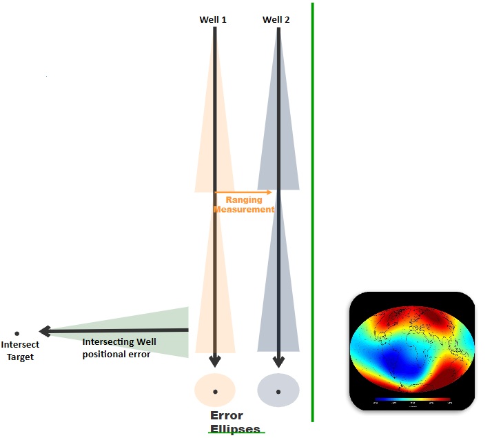
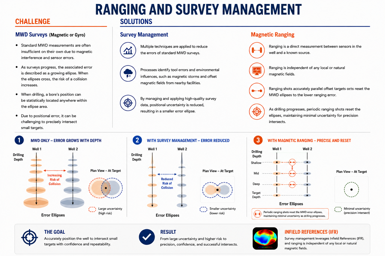
Standard MWD measurements are often insufficient on their own due to magnetic interference and sensor errors.
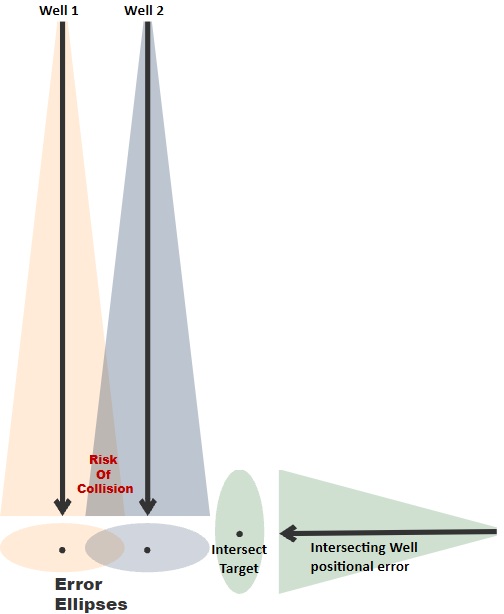
As surveys progress the associated error is described as a growing ellipse. When the ellipses cross the is potential of a collision increases
When drilling, a bores position can statistically be located anywhere within the ellipse area.
Due to the positional error leads to insufficient precision to intersect small targets.
SOLUTIONS
Survey Management
Multiple techniques are applied to reduce the errors of standard MWD surveys.
Processes identify tool errors, environmental influences like magnetic storms and offset magnetic fields from nearby facilities.
Magnetic Ranging
Ranging is a direct measurement by a sensor and known source.
Direct measurements have inherently low error and are unaffected by offset interference.
By using ranging we accurately parallel offset targets or reset the MWD ellipses to the lower ranging error
The error reduces as the sensor approaches the source making it possible to complete precision intersects.